
Cyclone Montha: Are We Ready for Montha Landfall on India’s East Coast?
Ready for Nature
 IN
Thu, Jun 25, 2026 | 02:34 AM IST
IN
Thu, Jun 25, 2026 | 02:34 AM IST

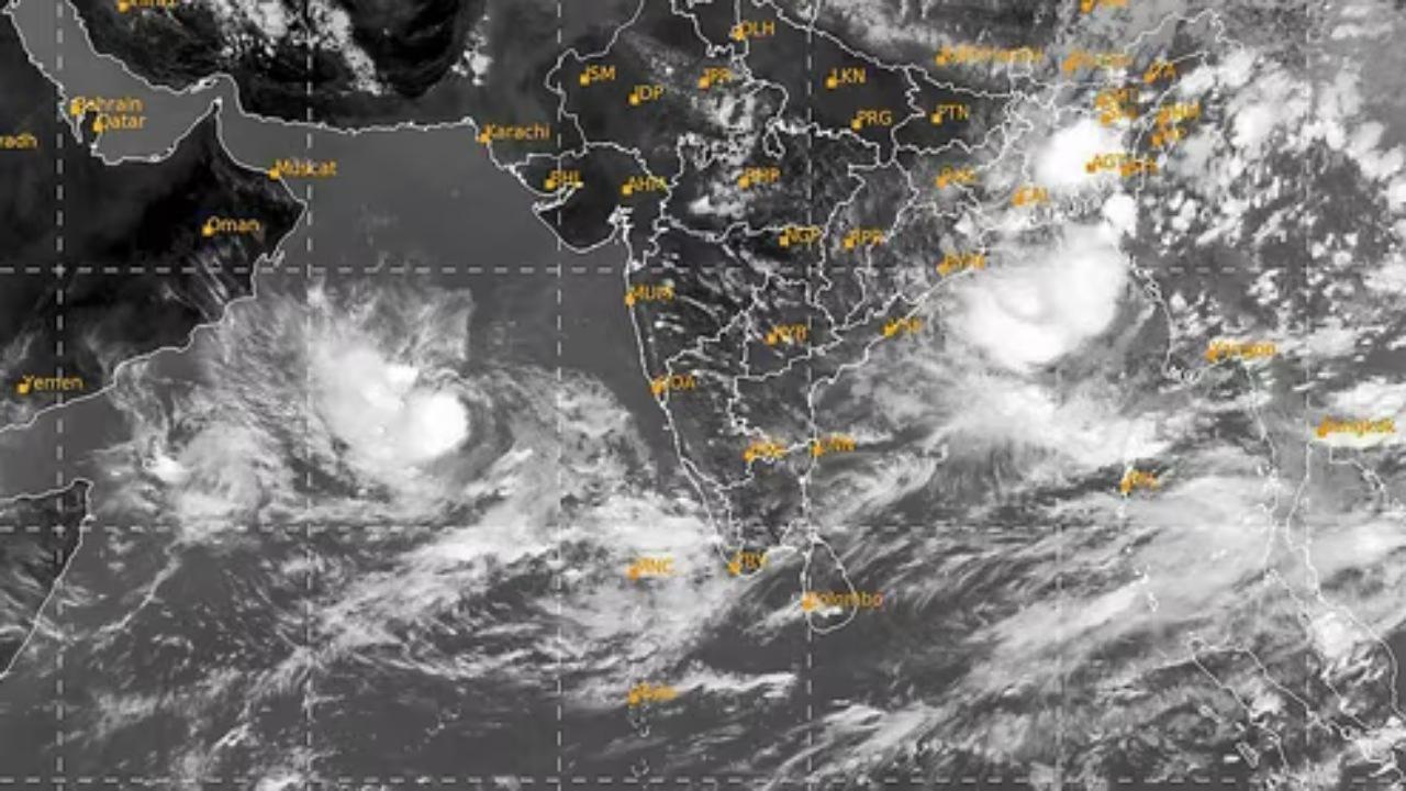
The east coast of India is looking toward the sea with concern. Cyclone Montha is strengthening over the Bay of Bengal and is expected to hit the Andhra-Odisha coast very soon. Weather authorities have issued red alerts India style for multiple districts, urging residents to take the warnings seriously.
That phrase Montha landfall is now everywhere-television screens, loudspeakers, WhatsApp groups. The message is straightforward: time is running short, and the storm is not slowing down.
The India Meteorological Department has signaled that Montha is packing winds near 90 to 100 km/hr, and stronger gusts are expected as the cyclone nears coastal towns. Heavy rain will begin before the storm actually touches land, which means some communities may start facing problems even earlier than they expect.
Many coastal families have lived through multiple monsoon systems, so “cyclone” sometimes feels like a familiar word. What matters is the combination: sharp wind, relentless rain, and sea conditions that can turn violent very fast. When they all hit together, lives can change in a few hours.
Low-lying coastal areas often face flooding first. Fishing villages and communities near river mouths are especially at risk. That is why coastal evacuations have already begun. Officials are knocking on doors in vulnerable pockets and asking families to move to nearby relief shelters. Government schools and cyclone centres have opened their gates to provide safe cover.
As preparation tightens, there’s already talk of weather disruption trains flights in major transit hubs. Trains scheduled along the coast are being cancelled pre-emptively. Flights may be grounded with little warning as visibility drops and gusts pick up.
People with rail or air tickets for trips toward coastal Andhra, Odisha, or regions close by need to stay alert. Even if your destination is not directly hit by Cyclone Montha, the ripple effect will spread inland. Buses may be stopped, highways barricaded due to waterlogging, and essential travel only may be allowed through some routes.
The next 24 to 48 hours will feel longer than usual for anyone dependent on transportation systems.
Markets near the shoreline are shutting earlier. Beaches have been declared off-limits. Fishing fleets are tied securely at harbours-boats that normally leave before sunrise are now anchored heavy, waiting for skies to calm.
The livelihood of thousands hangs in this waiting game. Fishermen face not only the fear of damage to their boats but also the loss of daily income. Many families in these districts survive day to day, and a cyclone doesn’t just threaten their safety-it shakes their economic foundation too.
Power departments have emergency repair teams in standby mode. Hospitals have stocked extra medicines and oxygen support. State disaster response units have positioned boats and rescue tools in vulnerable zones.
Schools in high-risk districts have been given notices to shut. Temporary shelters are being set up with food, blankets, water supply, and safe sanitation. Communication lines between local governments and village leaders are being tested repeatedly.
All of these are visible signs that the region has taken the warning seriously. But preparedness is never perfect. A storm like this can expose shortcomings quickly.
Whether you live right on the shore or further inland, now is a time to make practical decisions.
• Charge your phones fully
• Keep power banks ready
• Store clean drinking water and dry snacks
• Bring outdoor items indoors to avoid wind damage
• Keep emergency numbers easily accessible
• Ensure elderly family members and children have essential medicines nearby
• Avoid unnecessary travel until normal advisories resume
If an evacuation instruction comes, do not debate timing. Move quickly. Sometimes the decision to step out five minutes earlier can save a life.
Climate patterns across the Indian Ocean are shifting. Warmer sea temperatures give storms extra energy. They intensify faster and change direction unpredictably. In previous years, cyclones would build more slowly, giving people and governments longer windows to react.
Those grace periods are shrinking.
Coastal infrastructure-roads, ports, electricity networks, all have to adapt to storms that arrive faster and stronger. Communities that once felt they could ride out cyclones must rethink that attitude now.
As Montha landfall happens, several things are likely in quick order:
• The first hit will be powerful winds. Tin sheets, hoardings, and insecure roofs may give way.
• Then rain-heavy, sustained, flooding narrow lanes and rural stretches swiftly.
• With waterlogging, electricity may be cut deliberately to reduce risk of electrocution.
• Trees and poles falling can disrupt movement and communication.
The danger doesn’t pass immediately when the cyclone crosses the coastline. Remnants of the storm will move inland and continue to dump rain for hours or even a couple of days.
When television shows swirling satellite images and directional arrows, it is easy to forget the people who don’t have a safe home to lock themselves into. Some families along the Andhra-Odisha belt have their memories shaped by storms. They remember roofs flying, boats splintering, children crying in dark shelters.
They also remember resilience. Neighbours helping each other clear roads. Volunteers serving meals. The first sunrise after the storm bringing relief along with exhaustion.
There is always fear, but also hope.
Rumours move faster than wind during a crisis. Follow only verified announcements-state government, IMD updates, official alerts. Avoid sharing dramatic but false messages on social media.
If someone around you does not have a smartphone or constant access to news, check on them. Even a few minutes of information delay can turn risky when winds are rising.
Checking in on others doesn’t cost much, but it could matter a great deal.
Cyclone Montha doesn’t care about schedules, plans, or celebrations. What matters now is awareness and quick action. Those in high-risk regions must treat warnings very seriously. For people inland, this is still a moment to stay alert: the storm’s reach will be wider than its point of landfall.
This is a situation where staying home is safer than stepping out. And where saving your own life may help someone else too.
The United Indian believes the first gust of wind from Cyclone Montha will test more than coastal infrastructure. It will show how ready we are when nature shifts into attack mode. Maybe the storm weakens before it reaches land. Maybe not. But for those living along the eastern edge of our country, this is not the time to watch casually. It is a moment to prepare, and The United Indian will continue to remind readers that awareness and quick action are the strongest shields during times like these.
Everything you need to know
The danger depends on where you live. Areas closest to the shoreline will feel the strongest winds and the first flooding. If officials ask your area to move to a safer place, treat it seriously. Even strong houses can be affected when water rises or flying debris become a hazard.
Yes, it can. Heavy rain and strong gusts will travel inland after Montha landfall. Some places may face electricity cuts, blocked roads, and overflowing drains even if they aren’t directly hit by the cyclone’s center.
It’s smart to stock up a little. storms can disturb supply for a day or two - shops may close early, delivery services may stop, and clean drinking water might not always be available if floods enter pipelines. Keeping essentials at home isn’t panic; it’s preparation.
Once the wind strengthens and visibility drops, weather disruption trains flights becomes a real risk. Rail tracks can flood and airports may not safely operate aircraft. Transport shuts early to avoid accidents and to protect passengers, not to create inconvenience.
That depends on how much damage the storm causes. Usually, once winds drop and water drains, life starts coming back within a day or two. But repairs to power lines, roads, and communications can take longer in the worst-hit coastal places. Patience and cooperation help the recovery move faster.


Jun 18, 2026
TUI Staff
Jun 12, 2026
TUI Staff
May 28, 2026
TUI Staff
Jun 24, 2026
TUI Staff
Jun 20, 2026
TUI Staff
Jun 20, 2026
TUI Staff
Jun 17, 2026
TUI Staff
Stay informed with independent, fact-checked journalism on technology, environment, government, economy and more. India’s most trusted digital news platform.


Comments (0)
Be the first to comment!